Physical map of Europe

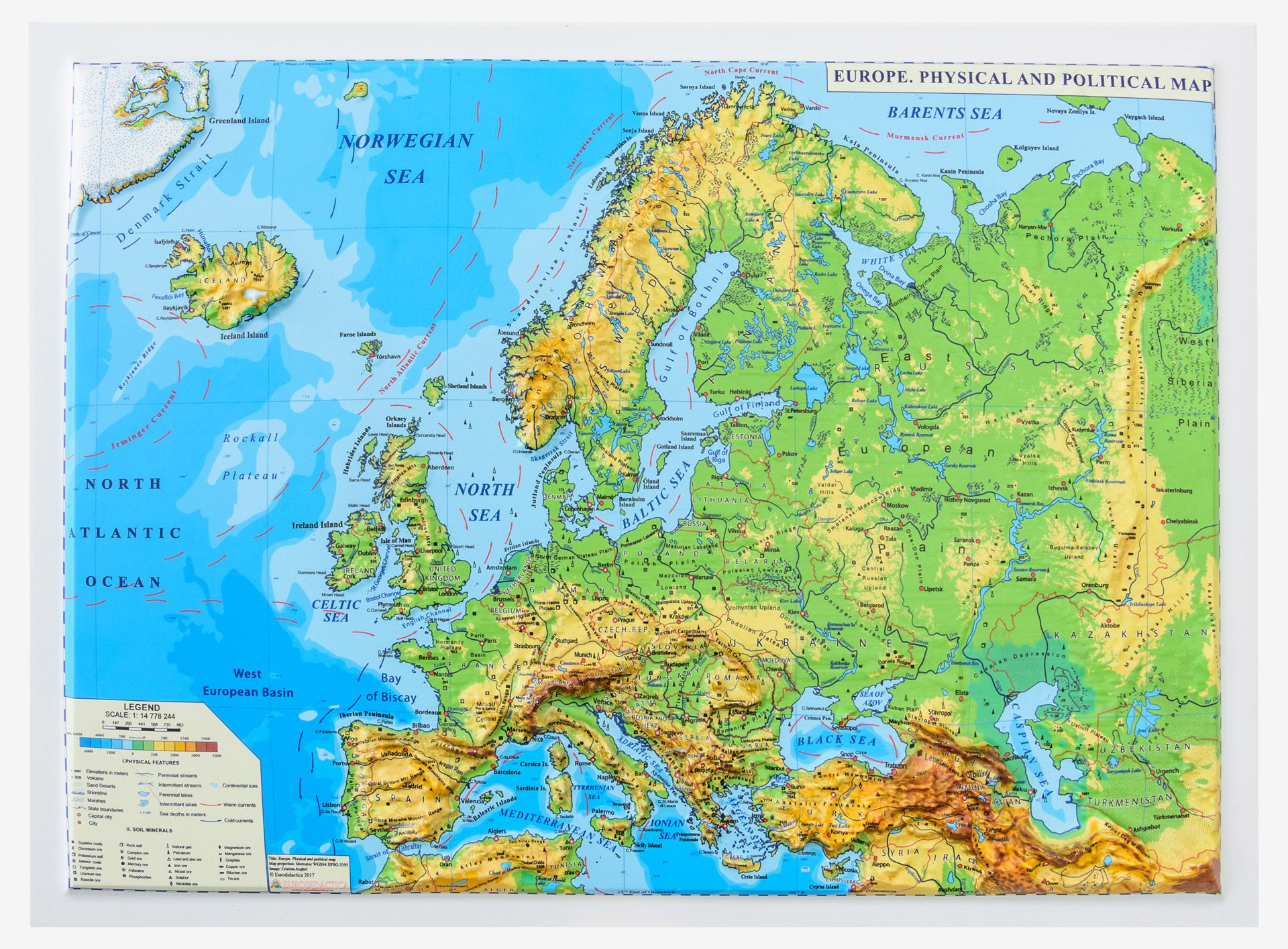
Look at the map and find out about the different landforms found in Europe ...

38 Comments on “Physical map of Europe

    • I am glad you liked the map, Vasiliki. What are the landforms you can see on the map? You can also give examples, ie. I can see the Aegean Sea and the Atlantic Ocean.

    • Nice, Kathrine,but you could name some examples. For instance, I can see mountain ranges such as the Alps.

  1. The map is Interesting! I can spot the Mediterranean and the north sea! It also shows a lot of mountain ranges such as the Alps!

  2. This map shows if a place has a lot of mountains or plains. And I think it’s called geomorphological map.

    • Yes, I think you are right! And it shows all kinds of landforms found in Europe. Mountains and plains are only a few.

  3. This map looks interesting. I can spot seas like the Norwegian Sea, or the North Sea. I can spot mountain ranges, such as the Alps. Though what seems fairly interesting to me is that Europe is mostly plain in its northern part, but mostly mountainous in its southern part.

  4. In the south I notice that it has more mountains and mountain ranges.Ιn the west I can observe the Atlantic Ocean.Ιn the center of europe and to the north I see more plains.The good thing about this map is that in each different territory it has a different color.Dark brown, light brown and green.This map is interesting.

    • Great, Pan! The different colours represent the differences in the altitudes (=the height above sea level).

  5. In the map i can see seas such as the Barents sea ,Norwegian Sea, or the Black Sea. Also i can distinguish and mountain ranges , for example the Alps. I think this map is very interesting .

  6. There are many gulfs,forests like Black Forest and seas like the Black Sea.Also, Europe has a mountainous continent ,because there are thousands of mountains.

  7. I really like the map. I can see the European plain but also the seas and the oceans that are around Europe like Atlantic Ocean, Barents sea ,Norwegian Sea, the Black Sea etc.I would find it more interesting if the letters were clearer (so you can see more details).

  8. This map is beautiful.I can see a lot of mountains and plains. Also I can see the Antlantig ocean, the Meditteranean Sea, and the Black Sea. In addition to, Europe has couple of lakes. Final Europe looks like a turtle.

  9. I can crearly see a lot of mountains such as Mount Elbrus. I can see many seas too such as the Black Sea or the Ionian Sea. Then I can also see islands such as Great Britain and Nothern Ireland. My opinion is that there a lot of mountains in the Southeast but in the North there are many plains. I can also see that on the West there is more water that the North, Southern or Eastern Europe.

    • Great, Zoe! It’s interesting that one can find all this information on a map. Northern Ireland is part of the island of Ireland. Do you mean to say that there are more water bodies such as lakes and rivers in the west than in other parts of Wurope?

  10. I can see mountainous areas near the Southern part of Europe and a flatter land in Northern Europe. There are many peninsulas in different countries. Russia is far away from any
    sea. I can also spot some seas, the Black Sea and the Mediterranean Sea. I think there should be more geomorphological maps,they’re very interesting.

  11. On this map I can found out the Norwegian sea, the atlantic ocean, the Aegean sea and how Mountainous is Southern Europe.

  12. In the map i can see the North Antlantic Ocean,norwean sea.barents sea and baltic sea

  13. It is really helpful and it shows where there are mountainous areas which can mostly be found in southern Europe, or oceans like the North Atlantic Ocean but of course, we can’t forget about the seas such as: the Baltic Sea or the North Sea.

  14. When I looked at the map i saw the Norwegian, the Barents and the North sea.Also the most mountainous part in Europe is in the west of Europe.I can see mountains like the White Mount in the Alps. The fact is that the most watery part in Europe it is on the west of Europe.

  15. This is a physical and political map of Europe. We can see different countries and different landforms.In southern Europe the landscape is mountainous but in central Europe there are plains. In the Mediterrenian sea there are many islands. England is an island by it self. I think by this map we can learn a lot of things.

    • Great answer, Erasmia! I loved your observation that there are a lot of islands in the Mediterranean.

Leave a Reply